NASA on Hasankeyf: There will be a cost
The article said that the effort is designed to help promote economic growth and energy independence for the country, warning; “But there will also be a cost.”
The article said that the effort is designed to help promote economic growth and energy independence for the country, warning; “But there will also be a cost.”

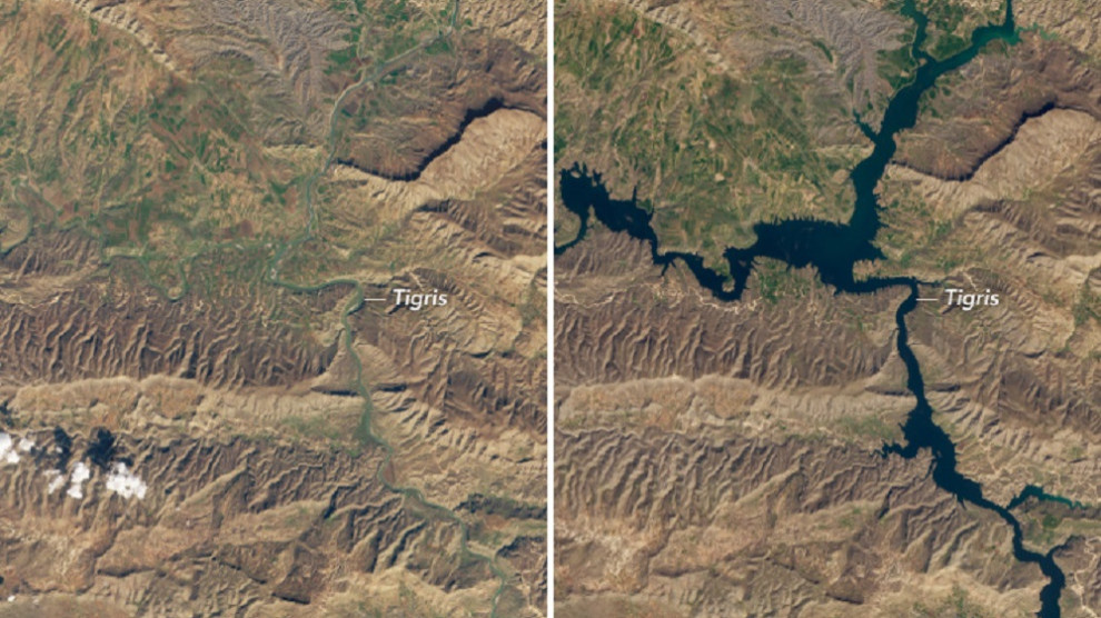
NASA Earth Observatory has published satellite images of 12,000 years old Hasankeyf town which has been flooded by a dam built by the Turkish state in the Kurdish region of the country.
An article published with the images includes the following:
“One of the oldest continuously inhabited settlements in the world, Hasankeyf, has been home to more than 20 cultures over the past 12,000 years. Early settlers carved caves into the surrounding limestone cliffs. Romans built a fortress to monitor crop and livestock transportation. Travelers on the Silk Road often stopped in the area to trade during the Middle Ages.
Remnants of past cultures have been preserved for thousands of years in Hasankeyf, which was absorbed by the Ottoman Empire in the 1500s and has remained part of Turkey ever since. But those artifacts—thousands of human-made caves and hundreds of well-preserved medieval monuments—may soon be underwater. A new dam and reservoir threatens to drown the city.
Located about 56 kilometers (35 miles) downstream of Hasankeyf, the approximately 135-meter (440-foot) tall Ilisu Dam is expected to provide 1,200 megawatts of electricity (around 1.5 percent of Turkey’s total power-generating capacity). The dam is part of Turkey’s Southeastern Anatolia Project, which consists of 19 hydroelectric plants and 22 dams on the Tigris and Euphrates Rivers.”
The effort is designed to help promote economic growth and energy independence for the country. But there will also be a cost.
Holding back water from the Tigris River, Ilisu Dam will create a reservoir covering 190 square kilometers (74 square miles) of land. When near capacity, the reservoir will almost completely submerge Hasankeyf and displace more than 70,000 people. Additionally, the dam will decrease water supplies to Syria and Iraq.
As of February 2020, water levels behind the dam were rising at a rate of about 15 centimeters (6 inches) per day. The reservoir is only about one quarter full and is expected to rise another 50 meters (160 feet) in upcoming months—enough to submerge thousands of nearby caves and nearly all of the Hasankeyf fortress previously occupied by the Romans, Mongols, and Seljuk Turks.
Some historical structures (including a tomb, mosque, and ancient bath) and all residents have been relocated to a new town on a nearby hill called New Hasankeyf (or Yeni Hasankeyf). Once the reservoir is full, a ferry system will shuttle people between the new town and what remains above water in Hasankeyf.
The natural-color images show Hasankeyf on February 22, 2019 (left) and March 12, 2020 (right). The images show the area near Ilisu Dam (located further downstream) on the same dates. The reservoir began filling in July 2019. These images were acquired by the Operational Land Imager (OLI) on Landsat 8."

NASA Earth Observatory images by Lauren Dauphin, using Landsat data from the U.S. Geological Survey. Story by Kasha Patel.
RELATED NEWS: